
A better understanding of water flow
Understanding the movement and availability of water locally and across the country is of paramount importance to both economic productivity and the human health of the nation.
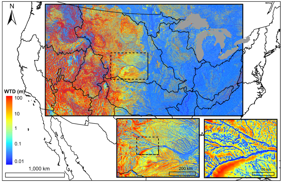
Decades of hydrology and computer science advances have allowed researchers to simulate U.S. water flow at high resolution on a continental scale for the first time, and a new $3.8 million National Science Foundation project led by Mines aims to put those state-of-the-science hydrologic models into the hands of a much broader audience.
Not only will HydroFrame allow field hydrologists to seamlessly test their own observations against national research and operational models—no software engineering background or supercomputer required—but farmers, city planners, forest managers, teachers and others will also be able to access the best hydrologic information available today through an easy-to-use online portal.
The grant from NSF’s Office of Advanced Cyberinfrastructure brings together computer scientists and hydrologists from seven institutions, forming a research team of experts in hydrologic processes, hydrologic model development, uncertainty quantification, data and workflow management, high-performance computing, performance portability and education and outreach.
“Having access to decadal, national-scale simulations is an unprecedented resource for both the hydrologic community and the much broader community of people working in water-dependent systems, whether that’s biological systems, energy or food production,” said Reed Maxwell, Rowlinson Professor of Hydrology at Mines and principal investigator on the project. “All hydrology builds on itself, and these simulations will enable the community to address research and operational questions about water availability and dynamics from the watershed to continental scale.”
The research team is focusing its efforts on two specific modeling systems. The Weather Research and Forecasting Hydrologic (WRF-Hydro) system, managed by the National Center for Atmospheric Research, can be configured to represent hydrological processes at continental, regional and local scales, depending on the questions being asked and purpose being addressed. It also serves as the basis for the National Water Model, which simulates streamflow over the entire continental U.S. and is run by the National Oceanic and Atmospheric Administration.
The other system, ParFlow, can also be scaled to run at the local, regional or continental scale but uses a more general subsurface flow solution scheme optimized for parallel computing and operates in a research capacity. Both are run on industry-leading science and research supercomputers, the complex systems requiring thousands of cores to operate.
Over the four-year project, researchers plan to both improve access to the models and further improve the models themselves, through additional computer science research as well as additional input from the larger hydrologic community.
“These modeling systems are the best reconstruction of the hydrology of the whole continent over the past decade we have,” Maxwell said. “We’ve already shown proof of concept—now, we want to bring the hydrologic community together and provide seamless access to not only just the results of these simulations but also input into how the simulations could be used in science or even shape how these models work.”

