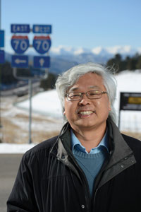
A slow, persistent landslide is undermining a short section of I-70, about a mile from the highest point on the nation’s Interstate Highway System. Finding a solution is a conundrum that one Mines professor is helping to unravel.
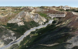 Two summers ago on I-70, about a mile from the highest point on the nation’s Interstate Highway System, a dip in the pavement grew so large that cars were going airborne and getting tossed out of their lanes. Fortunately, no one crashed before the Colorado Department of Transportation made repairs, but drivers shouldn’t rest too easy; the Big Bump will be back.
Located about a mile west of the Eisenhower Tunnel in Summit County, the Big Bump is a perennial headache for CDOT. The dip forms in the eastbound lanes on a slope-side stretch of highway perched hundreds of feet above Straight Creek. As spring snowmelt soaks underlying layers of rock and soil, the roadbed sinks a few inches every year. When it gets bad enough, CDOT repaves to level things out, but come the following June, the Big Bump returns.
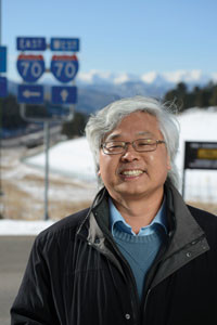
Professor Ning Lu has been working with CDOT for three years, seeking a long-term solution to the seasonal slope instability.
“At that point, the asphalt is now 6 to 7 feet deep,” says Ning Lu, a professor in the Department of Civil and Environmental Engineering, who refers to the slippage on I-70 as a slow-motion landslide. “CDOT keeps laying over more asphalt, but that’s just a short-term solution. With each passing year, the chance of a catastrophic event grows, and finding a long-term sustainable engineering solution is critical.”
CDOT turned to Lu, an international expert on landslides, in 2009. Since then, he’s partnered with the state’s engineers to gather baseline data about slope stability, with an eye toward developing a plan for a permanent fix.
“We started a field investigation there three years ago,” Lu says. “We put in sensors to measure embankment movement and groundwater table fluctuation in the slope over time. The main purpose of our research is to understand the configuration of the water table and soil, what type of soil is there, what’s happening with the water table.”
Lu found a clear pattern: “Stabilize, slide, stabilize, slide. But at some point, rather than 2 inches of subsidence in a year, there could be 2 feet of subsidence, and the highway would not be functional.”
That’s an outcome both Lu and CDOT hope to prevent.
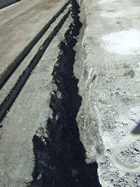
Every year since the 1970s, the eastbound lane has subsided a few inches during springtime snow melt. This fissure was found after asphalt was removed for repairs in summer 2012.
Over this stretch of I-70, the eastbound lanes are built on fill excavated from the tunnel in the 1970s. There is no subsidence on the westbound lanes, which sit more directly over bedrock.
Located at 11,000 feet, winter snowfall accumulations are considerable. By early spring, drifts at the edge of the highway often stand more than 10 feet high, and a snow-laden mountainside rises another 1,500 feet to the north.
“All that snow melts within a couple of weeks in the spring,” explains Lu, adding that the topography funnels surface runoff directly toward the area of the Big Bump. “As subsurface moisture content increases, the water table rises rapidly and the slope loses stability. Our monitoring results indicate that the water table rises by as much as 30 feet within the two-week snowmelt period.” It doesn’t help that there are two springs nearby.
“We’re looking at a dynamic process that extends from the surface to the water table and the underlying bedrock,” Lu says. “Precipitation alters the stress inside a slope, and when the stress state reaches its limit along the sliding surface, there will be a landslide. Sometimes it could take a few hours. Other times it could be weeks or years.”
Searching for a sustainable
The highway has sunk on a seasonal basis since it was completed in the 1970s. One of the primary concerns is that this consistent movement over four decades has defined a shear plane, an interface between bedrock and the material supporting the road that gets weaker with each spring melt. “It is likely that at some point in the future, accelerated sliding is going to occur if effective measures are not taken,” says Lu.
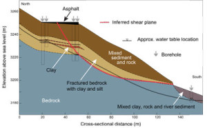
A hydrogeologic cross-section of I-70 looking east developed by PhD student Michael Morse illustrates the possible location of a weakening shear plane under part of the highway. Boreholes are used to gather data about the elevation of the water table during spring snowmelt.
Over the years, CDOT has looked at various options for permanently stabilizing the slope. One is to keep the area dry by channeling surface runoff away from the slide area and installing a network of subsurface drains. With adequate drainage, efforts could then be made to reinforce unstable soils with underground structures.
Another idea is to stack the eastbound and westbound lanes in an overhang configuration, as in Glenwood Canyon, so that both directions lie atop stable bedrock, but complex construction on this scale at this elevation would be very costly.
In addition, projects of this magnitude would necessitate closing I-70 for several months and diverting traffic over Loveland Pass, which would result in hours of delays, have a national impact on transit and shipping, and wreak havoc with state commerce and tourism. Such economic costs need to be considered along with the cost of construction.
“It would be very expensive to fix,” says Mark Vessely ’94, a former CDOT engineer who now works for the consulting firm Shannon and Wilson.
With no viable alternatives, CDOT resorted to an asphalt Band-Aid until last spring, when Vessely and his company devised plans to drill a series of shafts into the thick asphalt pad at the Big Bump and fill the holes with lightweight cellular concrete. “It reduces the weight and stress on top of the slide, and fills voids and loose soil beneath the pavement,” says Vessely. “The goal is to make some improvements and lower CDOT’s year-to-year maintenance costs, but it’s an interim measure. The long-term fix is still undecided.”
Probing the Rockies
CDOT spokesperson Bob Wilson says the department brought in Lu to help because of his insight and experience. Lu has studied landslides around the world as part of an arrangement between Mines and the U.S. Geological Survey’s Landslide Science and Engineering Partnership.
The team monitors numerous active landslide sites in Washington, Oregon, California, North Carolina and Colorado in an effort to develop simulators and modeling tools. When a major slide occurs anywhere in the world, Lu and his USGS colleagues are generally among the first investigators on the scene.
“The response team goes to take samples and data, make assessments, evaluate mechanisms, and find out how much stress and what particular type of soils were involved,” says Lu, who points out that landslides are becoming more frequent. The reason? The primary culprit is global climate change, he says. More energy in the atmosphere leads to more intense storms and precipitation.
“Any natural slope you see today is in a delicate equilibrium that has evolved over thousands of years,” Lu explains. “If you change the pattern, it’s going to alter the balance and possibly trigger a landslide.” For this to happen, the total volume of precipitation is less relevant than the intensity. A slow rain will produce different effects on a slope than an equivalent amount of rain that falls more quickly.
 Lu’s new book, ‘Hillslope Hydrology and Stability,’ published by Cambridge University Press and co-authored with USGS colleague Jonathan Godt, offers a comprehensive set of global landslide data, along with a new hydrological and mechanical framework for predicting and analyzing the likelihood of a major slide on a given hill slope or region. It answers questions not covered in his 2004 book, “Unsaturated Soil Mechanics,” published by John Wiley and Sons, co-authored with William Likos PhD ’00, a professor at University of Wisconsin-Madison, which has become a go-to reference for civil engineers around the world. Still, he says, landslide forecasting has lots of room for improvement.
CDOT renewed the research contract with Lu and Mines Associate Teaching Professor Alexandra Wayllace for another three years. During that time, the asphalt at the Big Bump may grow another foot deeper. But Lu’s body of soil and water data will grow deeper as well and, he hopes, yield the information necessary to formulate a strong long-term solution.
What are the chances they’ll be able to finesse the problem and avoid massive disruption and expense? “Once we know more about subsurface fluid flow and stress variation patterns, we’ll be in a better position to know if conditions can be changed to stabilize the slope in a natural setting without major overhaul,” Lu says. “The key may be controlling groundwater table levels within the highway embankment. That could happen, and it could be economical and sustainable.”
Engineers at CDOT certainly hope so. “We’ve been patching this over for too many years,” says CDOT’s Wilson. “Eventually you have to fix what’s broken.”

